closer to Dunners than the earlier posts about Mt Maunganui and Ohakea. I think this thread morphed a wee while ago into more than just Dunedin.


closer to Dunners than the earlier posts about Mt Maunganui and Ohakea. I think this thread morphed a wee while ago into more than just Dunedin.
Te Pirita was the start point for a very long and localised history in Central Canterbury. The Motor Racing Club and Canterbury Car Club are a large part of that. They deserve - and have - their own history.

It did indeed Graeme as I didn't want to start another one to keep an eye on.. Now covers most events outside of Auckland,Originally Posted by jellywrestler

Auckland events - Ardmore and others Whenuapai etc will put on the Pukekohe thread.
Just haven't got around to get TRS to amend the Title - covered in the first post though, which has been amended several times !!
Cheers
Roger
Greg T, Thanks for that - must do some research on the MRC and CCC ..
Do you have some information on Te Pirita .. I thought it was further South than Canterbury - off to Google now !!
Cheers
Roger
Should have gone to Spec-Savers.
Just word searched ' Te Pirita ' on this forum and found it mentioned by " jellywrestler " on a separate thread and in " Old Race Tracks." too - found my own post and this ;
Was near Christchurch and a long way from Dunedin - but at least I had it in the proper Island !!
Until recently I lived in Hororata which is the nearest settlement of any size. Having known for years about Te Pirita being used I did ask one or two of the locals for any info. Not being a born and bred local myself. I'm told there's pretty much nothing left of what was the airfield. It was after all only a grass strip - like Wigram - but without Wigram's sealed perimeter track. That area is all relatively recent conversions to dairy. Within the last 20 years or so anyway. I suspect you'd be hard put to see any evidence even from the air by now.
I knew about it from listening to talk at home - the old man was a founder member of the Motor Racing Club.
There is a massive tome published on the history of the Motor Racing Club. Your local library may have a copy, Christchurch certainly does. They come up occasionally at swap meet stalls. Cheapest I''ve seen was $100 which is why I don't have a copy.
Allan - missed your comment - post #299 now suitably corrected - Thanks for the information.
Cheers
Roger
sounds like you need one of my books....
https://www.google.com/maps/place/Te...4!4d171.893538
there is a slight trace on google maps, i flew over there recently and at that time of the year couldn't see anything at all, pretty cool feeling to see seagrove air base still clear as from a plane up north. I have become friends with a guy called Max Poole, he was a child on Seagrove shortly after the war, I took him out there recently and loved his guided tour of where everything was there too.
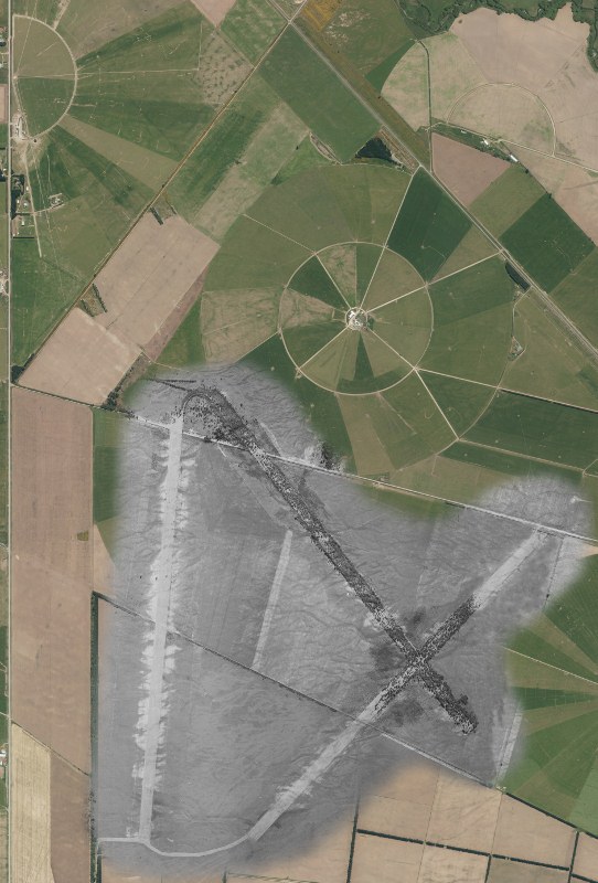
quite a mission merging old aerial photos into modern maps, first is to get them both to the same direction then get the scales to match. This on was harder as the black and white is made of more than one aerial merged too, it's just a patience thing but no-one else could pinpoint the facility.
that's actually the original programme fo the event, damn lucky to find that, it was in the Vintage Car Clubs archives. They have a lot of old programmes and initially had brushed this aside as a drag race type of event untill I googled the venue and found at the time it was new zealands biggest airfield. I returned the next week to the VCC archives and found the events were listed including laps so a proper race meeting as such. Andy Anderson the last surviving founder of the VCC went to the meeting, I need to track him down and see what his memories are of it. The brick structure that stored aviation fuel for this is still in the ground at bankside very close to SH1 and has been deemed of historical interest
You know Kevin Clarkson don't you Spyda. Chairman of Beaded Wheels editorial comittee. Used to race in CAMS and his son Brent still does occasionally. Kevin would I'm sure put you in touch with Andy anderson.
Slightly irrelevant, but I was taken to see Te Pirita airfield remains in 1970 when I was teaching at Dunsandel in 1970. Largest airfield? That's surprising. FWIW Dunsandel Rugby club played in the South Canterbury sub section, although most other areas defined the boundary as the Rakaia river.
I believe the local garage owner, Ivan Happer raced there.
Ivan quite probably did race there. He's long gone now, Happers honda is now run by a grandson.
I beleive when it was built it had the longest runways. It was far enough inshore to not be shelled by warships I would guess is why it was put there. Ivan was a good friend of mine, I've got his old King Dick V Twin.
yeah have to get onto it. It's not cheap to travel within nz anymore, my two rental car compaines have put their prices up, one tripled and the other quadrupled, flights are a lot deare, instead of getting a three day weekend for around $150 travel and car it's now many times more, gonna have to rethink moving around the country bugger it all.
I thought Waharoa was vastly bigger, at least judged by the planes that were there, and having walked both! Ivan vowed and declared he hadn't bought a car from me which he paid me money for! (And his daughter crashed my MGA when it was in for a WOF!)
The airfield was constructed in record time using seconded civilian and New Zealand Armed Forces engineers. Three heavy earth compacted runways up to 2,000 metres (6,600 ft) long were laid in the prevailing wind directions of the region. The runway surfaces were laid with wattle tree seeds for strength while the base was designed to handle large numbers of US Boeing Flying Fortress and Consolidated Liberator bombers.[1]
where in waharoa was the airfield, i'll measure them and see what i can see
where in waharoa was the airfield, i'll measure them and see what i can see
Waharoa is still in the same place that it was when built during the war. Alongside SH27 Now showing on Google maps as Matamata Aerodrome. It has lost some length off both runways, the predominant one almost parallel to SH27 originally went as far south as Wardville Road, and the cross wind runway (shorter) went further west. It had the perforated metal strip, as used in the Pacific Islands under the surface as recently as the early 70s to my positive knowledge. The part at the southern end now not used was prohibited from being ploughed then in case it was needed again at the same time.
During the war US bombers were stationed there, I am unsure exactly which variety.
 Posting Permissions

 Reply With Quote